
In a unique partnership, the Georgia Department of Transportation is allowing use of public land along a major highway in Atlanta to be converted to a bustling green space that promotes walking, biking, and recreation.
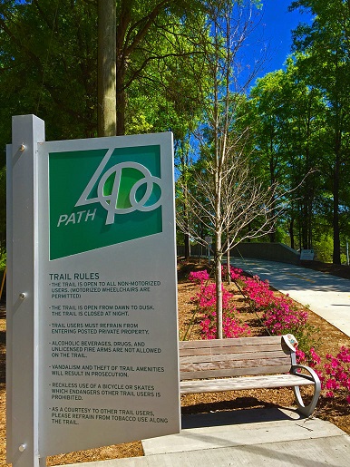
The trail project, dubbed PATH400, is a 5.2-mile greenway being constructed on public land adjacent to GA400. The trail, which extends toward the northern edge of the city, will link residential, commercial, and retail locations and is the centerpiece of a broader greenspace plan. It was spearheaded by a local nonprofit, Livable Buckhead, along with the Buckhead Community Improvement District and the PATH Foundation, and is being implemented in partnership with the city of Atlanta, Georgia DOT (GDOT), and other agencies.
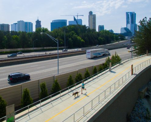 The project came about to address the lack of trails and recreational options in Buckhead, an upscale residential and commercial district in Atlanta. Facing potential costs of $10-15 million to acquire land for a trail project, Livable Buckhead set its sights on the unused public land adjacent to the GA400 corridor, which runs north-south through the district.
“Their idea was to repurpose the right-of-way on State Route 400,” said Kim Nesbit, State Program Delivery Administrator with GDOT. The nonprofit and its partners worked with the city to develop a memorandum of understanding with GDOT, allowing use of the public land to construct a trail through the community that eventually will link to Atlanta’s regional trail network.
The unique memorandum of understanding – entered into between the city of Atlanta, Georgia DOT, and the State Road and Tollway Authority – grants permission for the city to create a trail on SR400 right-of-way. The agreement provides for the trail to be constructed primarily on GDOT right-of-way, but also includes areas on city-owned streets as well as rail and transit rights-of-way owned by the Metropolitan Atlanta Rapid Transit Authority (MARTA) and Norfolk Southern Corporation.
Under the agreement, the city was responsible for construction, with the nonprofit PATH Foundation serving as project manager. The city also took responsibility for ongoing maintenance and landscaping of the property, while GDOT retained full ownership of and access to the land. Livable Buckhead was responsible for the project design.
The project is being completed in phases, with the first of several phases now complete and open to the public.
Benefits
The benefits of PATH400 include increasing access to community amenities such as arts, historic, and cultural exhibits; neighborhood parks and greenspaces; and retail centers. It has created new connections within the community, allowing residents to bike or walk to work or use the trail for recreation.
The path brings together 8,000 residents within a 10-minute walking distance, while also providing direct access to the Buckhead and Lindbergh MARTA stations within Metro Atlanta as well as the North Springs and Dunwoody trails through future phases.
 “There is no one solution for mobility for Georgia and Metro Atlanta. It is a multitude of approaches that have to play a role,” noted GDOT Commissioner Russell McMurry. “Along with keeping our infrastructure in good repair, Georgia DOT focuses on the future of mobility to keep Georgia competitive, both now and in the years ahead. That’s why we always keep an eye on mobility enhancement through connectivity and transportation choice.”
Challenges and Lessons Learned
Denise Starling, Executive Director of Livable Buckhead, said challenges in implementing the project included overcoming fears that the trail would bring crime into the community. To help allay such concerns, the trail was designed with limited entry points at which security cameras – maintained by the city – were installed.
“Once the first half-mile of the project was built, it changed the ball game,” she said. “People saw the quality of what we were doing and that it didn’t bring in crime and the other things they were afraid of.”
“From a planning perspective, one of the biggest lessons was that public engagement is more important during construction than it is during planning,” Starling said. That’s when people are most inconvenienced, and that’s when they want information. During that time, she said, it’s best to maintain direct communications with the neighborhood, ensuring that promises made during planning are kept as the project is constructed. “For any transportation project, that’s a huge lesson learned,” she said.
GDOT’s Nesbitt said other challenges included meeting accessibility requirements along areas of the trail with steep terrain, which required obtaining some variances and installing signage indicating some areas had limited accessibility. Project partners also incorporated design features to ensure emergency vehicles were able to access the trail, she said.
Nesbitt said she absolutely would recommend that other state DOTS undertake similar projects to repurpose highway rights-of-way, especially in urban areas where the cost of property can be prohibitive.
Getting People to Use it
According to Starling, a key aspect of building the trail has been getting the word out and getting people to use it.
To that end, a variety of public outreach efforts and events have helped generate enthusiasm and support for the trail. These have included a community party; a running club and 5K event; dog training; public art projects including murals along the trail; and ongoing, direct interaction with community members.
 “It’s not just about putting down a trail,” Starling said. “It’s about the experience. You have to really own it and make it part of the character of the community.”
The Path400 project was recognized as a winner of AASHTO’s America’s Transportation Award and was recognized in AASHTO’s Benefits of Transportation initiative.
For more information, link to the PATH400 website or visit the Path400 page on the Livable Buckhead website.