
The Pennsylvania Department of Transportation is using an innovative “Story Map” to share important historical information about an area impacted by a road improvement project on Route 322 in Centre County.
Background
The online interactive map provides locations and details about historically significant sites, people, and events within the area of the Potters Mills Gap Transportation Project. Users can learn about the history of the project area and its inhabitants, including the town’s namesake James Potter, Native American settlements, log structures and historic homes inhabited by early settlers, early roads, farms, industry, cemeteries and other features. This effort to document the area’s history is part of an innovative effort to mitigate project impacts on historic resources in the project area.
The road improvement project along a section of Route 322 required mitigation for adverse impacts on several wooded tracts, historic buildings, and historic farmland areas within the Penns/Brush Valley rural historic district. The district was determined eligible for listing in the National Register of Historic Places based on its agricultural patterns, associated landscape features and Vernacular-style architecture established during the nineteenth and twentieth centuries.
The Story Map, titled A Journey to Potters Mills, is the first of its kind to be used by PennDOT to help mitigate adverse impacts to historical resources.
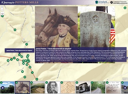
Screenshot of Journey to Potters Mills Story Map. Courtesy: PennDOT
“The intent of the Story Map is to provide the public with insight into how the development of transportation within the Potters Mills Gap has, over time, impacted the Historic District,” said Karen Michael, PennDOT District 2 Executive.
According to a PennDOT summary, the Story Map provides visitors with a visual and geographic history of an important crossroads in the Seven Mountains region of the Commonwealth. The map “allows visitors to change scale and navigate between important historic places along the highway corridor and understand the roles that transportation, natural resources, agriculture and early industries played in the development of modern Centre County.”
The Story Map website provides an interactive map of the area with 33 separate image icons that link users to important locations – along with photos, historic maps and documents and a brief description of each. Together, the map allows users to explore the history of the region, from the time of the Native Americans and earliest settlers through various important historic events and locations.
The team sought images which spanned the development of the area, and included diverse subjects and formats including photos, historic maps, portraits, documents, and other records. Information was uncovered through research at a number of repositories, including local historical societies, universities, libraries, state agencies, and from private individuals.
Origins of Story Map Concept
The Story Map concept was proposed to PennDOT by its project consultant as a possible mitigation measure for adverse impacts identified for the project under Section 106 of the National Historic Preservation Act.
“The idea actually came from one of the consultant team members who saw a social media post that combined a map, text and images, but lacked the GIS-based interactivity of what became the Story Map,” according to PennDOT’s Steve Fantechi, who managed the project through preliminary design.
The Story Map was one of a number of mitigation measures that included roadside interpretive signage, context-sensitive design measures, the preparation of a “Best Practices” document, and avoidance and protection of some resources. The NEPA document for the project was an Environmental Assessment that concluded with a Finding of No Significant Impact.
According to Fantechi, the Section 106 consultation process involved a great deal of consultation and interaction with local historical societies and local governments. “That collaboration contributed substantially to Story Map’s popularity with local residents, the regional press, teachers, and citizens and engendered a substantial amount of local and regional pride in local heritage,” he said. “In our view that’s what a successful Section 106 outcome looks like.”
In addition, he said, the GIS-based Story Map approach also creates an obvious link between landscape, transportation networks, and economic history, which in turn promotes a better understanding of and context for historic events, trends and places.
To the best of PennDOT’s knowledge, this is the first mitigation product of its type used for an American transportation project.
Challenges and Lessons Learned
According to PennDOT District 2 staff, the biggest challenge in developing the Story Map was probably too much of a good thing.
Background research and interaction with the consulting parties produced an enormous number of images and a substantial amount of local history and documents. Paring that down to a relevant and manageable record of local and regional history was a challenge.
Once that work was done, the actual GIS programming required to produce an interactive and useable online product had its own set of challenges, as the product went through a number of iterations leading to the final version.
Another challenge came from requests by some of the consulting partners to add additional information to the Story Map for future projects. Since PennDOT used a consultant to develop the Story Map, its ability to revise the map was limited to the duration and funding of the consultant’s contract. PennDOT doesn’t have the resources to revise the Story Map in-house, so future revisions, which could involve different consultants, could be more difficult, according to PennDOT Project Manager Craig Sattesahn.
Regarding lessons learned, Sattesahn said it would have been useful to establish procedures and parameters up front to facilitate revisions and additional requests.
Advice for Other DOTs
According to PennDOT staff, close and meaningful consultation with local consulting parties and residents is key to local support for the product and can help obtain a great deal of important local input – such as family images, diaries, etc. – that would be impossible to get anywhere else.
It’s also important to balance high-tech and low-tech mitigation measures. Older residents are less technologically savvy than younger ones, and there are still many remote locations where high speed internet conductivity is spotty.
Since the Story Map is a technology-based product, the rapid change and evolution of technology requires attention. Although no funding is available to carry the Potters Mills Gap Story Map further, it’s likely that the next iteration of a Story Map on a different project would probably be a mobile application.
As a final consideration, PennDOT staff said a central online state repository for Story Maps from multiple projects is probably worthwhile and would not be a very expensive effort. Such a site would allow visitors to start a search at the state map level and zoom in to a number of specific project areas that have Story Maps.
The first of three construction sections of the Potters Mills Gap Transportation Project was completed in 2015. A second section began construction in August 2016, and the last section started construction in early 2018.
For more information, link to A Journey to Potters Mills Story Map and the project website.