
In the wake of the devastating floods wrought by Tropical Storm Irene in 2011, the Vermont Agency of Transportation is working to expand training and awareness on how to properly manage highway infrastructure in concert with the natural ebb and flow patterns of the state’s river systems.
Irene’s torrential rains and flooding washed out or damaged hundreds of miles of roads and hundreds of bridges and left entire communities stranded. In its wake, Irene also taught an important lesson: the need to manage the state’s road infrastructure to be more compatible with its streams and rivers.
Irene’s devastating floods “changed the way we do business in Vermont,” according to VTrans Deputy Secretary Rich Tetreault, who served as the agency’s Director of Program Development and Chief Engineer.
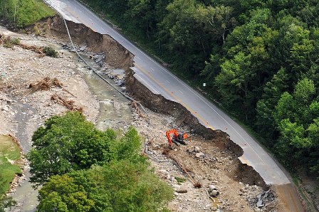
In-stream restoration work following Tropical Storm Irene. Photo: VTrans
Tetreault said VTrans employees are being sent back to the classroom for coursework on the science of rivers. Also known as “fluvial geomorphology,” this science stresses how natural cycles of periodic flooding and deposition allow river systems to reach a balanced state known as “equilibrium.” Both online and classroom training is available. The contents, which are grouped into three tiers ranging from basic to advanced, have been developed by engineers at the Vermont Agency of Natural Resources.
Managing for Equilibrium
The Tier 1 training – which also is used by ANR for its own staff – is an online self-guided basic course that describes the value of rivers and hydrologic and sediment regimes; explains river behavior, including river morphology, river equilibrium, and channel evolution; discusses rivers and human development, including flood and erosion hazards and efforts to control rivers; and explains how best to manage rivers for equilibrium.
The course summarizes the following key points about river processes and management:
- Rivers have a natural level of stability that is realized when the power of the river flow is in equilibrium with the sediment load.
- This balance can be tipped when activities on the landscape or in the river change the amount of flow and sediments delivered to the rivers and/or the power created by the flow and resistance provided by the river channel.
- When the balance is tipped, the river enters a disequilibrium condition and potentially a channel evolution process and the threat to property and developments is increased.
- Working with the natural tendencies of rivers to manage for equilibrium is the most cost effective way to reduce river related damages and threats to public safety.
The training helps professionals learn how to better identify areas with severe erosion hazards, how best to mitigate areas where damage has occurred, and how to better design roads and features to avoid future damage. It is applicable to a range of transportation professionals including engineers, technicians, equipment operators, and highway foremen.
“This goes from the hydraulics engineer to the bridge and roadway designers, to the local road foreman and the excavator operator that’s working in the river, so they all better understand the dynamics of the river when they are working on public infrastructure,” Tetreault said. At the same time, the training is being provided to local agency partners and contractors.
The Tier Two training is a classroom and field-based training that delves more deeply into the topics of physical river processes, aquatic habitat and the interactions between rivers and adjacent infrastructure. It also explains the permitting process and standards that must be met. Emphasis is placed on accommodating stream equilibrium, avoiding practices that trigger further instability, and minimizing impacts to aquatic habitat during emergency flood response and recovery operations when technical support is not available. Contents are particularly geared toward design, construction, maintenance and planning professionals.
It includes “a lot of hands on work, both in the classroom with custom built flumes and in the field, knees deep in a local stream,” said Scott Rogers, VTrans Director of Operations. “We have mandated some of our folks from the maintenance garages attend Tier 2 to become more intimately familiar with the dynamics of the systems. They are the ones running the equipment (or making the decisions on repair work) in the field,” he added.
In 2015, the Tier 2 format was modified slightly to mix participants from VTrans with those from municipalities. In addition, a special training was held for regional planning commission transportation planners and another for private sector engineers. Mixing participants allowed for state-municipal dialogue that resulted in technical transfer and the development of greater appreciation for differing perspectives.
The Tier 3 training currently is under development, with completion scheduled for spring 2016 and training sessions to begin near the end of 2016. Tier 3 will focus on advanced engineering and construction oversight topics, specifically the design and construction oversight of the stream alteration practices outlined in the Vermont Standard River Management Principles and Practices document (2014).
Codifying the River Science Approach
In addition to offering the training courses, VTrans has updated its hydraulics manual to codify the “river science” approach. While the previous manual was based on the hydraulic capacity of infrastructure – focused strictly on water – the revised manual also considers sediment and debris.
The new manual allows for more risk-based design in terms of roadway safety and stream stability. It also corresponds to VTrans’ latest stream alteration permit, codifying a process that currently is required under permit but not recognized as a standard by authorities such as the Federal Emergency Management Agency (FEMA).
“The new manual doesn’t change the hydrologists’ methodology. It codifies it such that when FEMA comes to town we will have another documented standard to fulfill when they are replacing public infrastructure,” Tetreault said.
For example, where slope repairs are needed adjacent to rivers, workers historically had dumped stone down the slope, further constricting the river channel. Such repairs now would start with defining the stable channel dimensions for the river and then building the slope to match – all with the help of fluvial geomorphologists. “Across the board, we are really making this part of our standard operating procedure,” Tetreault added.
Understanding River Systems
Tetreault said that the “river science”-based approach is important for all ongoing activities of maintaining existing infrastructure, up to and including reconstruction or new construction of highways. For example, such considerations are important when addressing a culvert replacement or a slope failure or a river channel that needs some adjustment to respond to the built environment around it.
“There is a dynamic going on continuously with the rivers, and there is maintenance going on with drainage systems or even the river itself. People need to be aware of the fact that the river is working and we need to work with it and understand the changes that occur over time,” he said. “So the minute you get an excavator out and you’re working near a river, stop and think: if I put this rock here or if I remove this tree trunk here, what is it doing to the dynamics of the river as it is now and will be in the future?”
Tetreault said other states with river systems could benefit from the self-administered training course, which is posted online and is free of charge. The Tier 1 training course can be accessed online.
For more information on Vermont’s Rivers and Roads program, contact Richard Tetreault, [email protected] or link to the training summary.