
The Virginia Department of Transportation’s (VDOT) evolution to an environmental data management system started with more than 73 decentralized spreadsheets and personal databases. In 2001, VDOT developed its GIS Integrator, an internal geographic information systems (GIS)-based tool to support the agency’s efforts to improve early project development and environmental review by capturing a spatial inventory of project shapes used to identify existing environmental resources with the potential for project impact through spatial analysis.
Background
In 2003, VDOT expanded their data management solution by consolidating all non-spatial data sources into an environmental data repository called the Comprehensive Environmental Data and Reporting system (CEDAR). This internal web based application provides a single user interface for capturing all VDOT’s environmental business data, including National Environmental Policy Act (NEPA), permitting, and environmental contracts. The CEDAR application synchronizes nightly with the agency’s project pool and active directory databases for improved management of project data and user accounts. It also links to the agency’s GIS Integrator, which allows for streamlined project reviews.
“The CEDAR system provides VDOT staff with an invaluable comprehensive environmental data management tool that has successfully improved communication and accountability, said Geraldine Jones, VDOT CEDAR Administrator. “Since its deployment in 2003 CEDAR has been the backbone of VDOT’s environmental operations. CEDAR’s success, usability, and permanence can be attributed to its user championed platform and staff dedicated to maintain and enhance an application subject to dynamic regulations and processes,” she said.
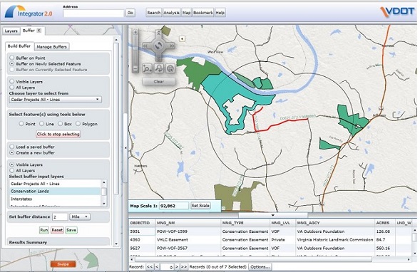
The GIS Integrator allows users to buffer project shapes to determine potential resource issues. In this case, the project shape was buffered 2 miles for conservations lands. Source: VDOT
The integrated CEDAR system centralizes where staff enter and retrieve data for all VDOT’s environmental activities on a project-by-project basis, allowing for restricted viewing and editing based on roles and permissions. It captures project history, handles all project types – including construction and maintenance – tracks project status through the life of the project and generates system alerts.
The system also:
- stores, manages and distributes documents;
- contains a task assignment function;
- tracks commitments;
- documents project details such as meetings and phone calls using the journal feature;
- contains links for environmental permit tracking and houses regulatory agency correspondence;
- links to VDOT’s Integrated Project Manager (IPM) system, which contains project pool information;
- links to the GIS Integrator, which allows for digitizing project shapes and spatial analysis functionality to identify environmental impacts in a project area;
- includes both standard and ad-hoc project reporting such as new projects, tasks schedule, and advertisement schedule; and
- provides access to project contract and other administrative information.
Benefits of the system include increased project accountability, satisfaction of mandates, and interagency coordination. It also provides documentation for decisions, and offers a tool for communication of commitments, project status, accuracy of project estimates, and efficiency of projects.
Current Efforts and Key Take-aways
Today, VDOT’s CEDAR and GIS Integrator applications are positioned for upgrades. A user advisory committee has been formed to identify functional requirements. The upgrade is expected to come with an updated user interface and be launched within the foreseeable future.
Key motivators for an integrated environmental data management system as exhibited by VDOT’s CEDAR and Integrator include the following:
- Economic savings: Compared to “pre-CEDAR” 2003, VDOT environmental projects in 2011 experienced notable time savings. For example, the labor hours required to complete tasks associated with a project categorical exclusion (such as a biological assessment, state environmental review, or field survey for endangered species) decreased between 33 and 50 percent.
- Process efficiencies: CEDAR consolidates applications (project management, GIS, data storage) and makes it easier to document environmental decisions and communicate environmental commitments and project status.
- Quality control improvements: CEDAR provides standardized spatial data and pre-approved data schemes. It provides a basis for program management and trend analysis.
- Interagency coordination and relationship building: CEDAR helps streamline interagency coordination by supporting compliance with mandates, reducing the time required for advancing projects through regulatory approvals, compiling all external agency communication, providing transparency of environmental data from all participating entities, and increasing the visibility of project.
Transferability
VDOT is not alone in its development of an environmental data management system. Though many state DOTs still use spreadsheets, databases, paper maps, and shapefiles as data management tools, many others have developed standalone systems or contemplated environmental data management systems of their own. In August 2015, numerous state DOTs gathered in Oregon and online to discuss data management approaches in their agencies in an effort to share information and experiences across agencies.
VDOT’s advice to other DOTs interested in their own data management systems includes supporting an IT staff dedicated to application maintenance, and involving users from the beginning to confirm requirements and increase staff adoption of the system.
For more information on VDOT’s CEDAR, please contact Geraldine Jones, CEDAR Administrator, VDOT Environmental Division, at [email protected].