
Transportation officials in Minnesota will be better able to assess vulnerability of transportation assets to flooding and select appropriate adaptation options for damaged and at-risk infrastructure following a pilot study conducted by the Minnesota Department of Transportation. “The potential for more frequent extreme precipitation is a major risk facing our state’s aging transportation system,” said Philip Schaffner, Director of Minnesota DOT’s (MnDOT) Flash Flood Vulnerability and Adaptation Assessment Pilot Project.
The project is one of 19 Federal Highway Administration (FHWA)-funded climate vulnerability pilot studies that were carried out between 2013 and 2015. Each of the studies drew from guidance contained in FHWA’s Climate Change and Extreme Weather Vulnerability Assessment Framework (FHWA Framework).
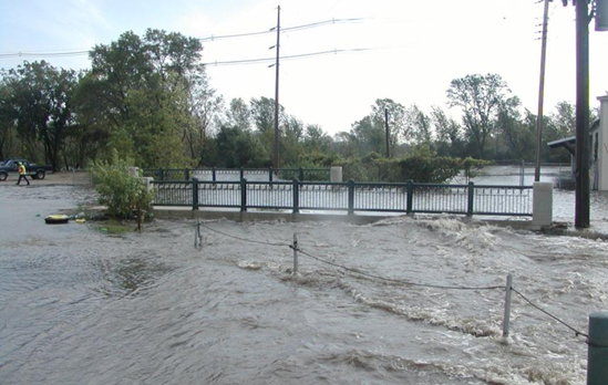
Minnesota DOT’s climate vulnerability assessment is helping the agency address threats such as this flooded culvert in District 6. Photo: Minnesota DOT
The timing for the project could not have been better, Schaffner said.
In 2012, he explained, MnDOT had just identified climate-related flooding as a major risk to the system in the state transportation plan when Duluth experienced the worst flooding it had seen in centuries. It resulted in more than $100 million in damage to roads and other infrastructure. Other parts of the state also had recently experienced significant flooding. The state’s transportation system assets had not been originally designed to handle such extremely high levels of precipitation.
As it happened, Schaffner continued, at that same point in time, FHWA issued its second-round call for proposals to carry out pilot projects examining the effects of climate hazards on transportation systems. Unlike the broader first round of 2010-2011 pilots that primarily involved coastal locations, projects located inland were especially welcome.
MnDOT’s study had four goals:
- Better understand the vulnerability of the state’s trunk highway system to flash flooding;
- Increase system resiliency by developing a methodology to identify cost-effective design solutions;
- Support the agency’s asset management planning work; and
- Provide feedback on the FHWA Framework.
One of the first steps taken was to create two technical committees to support the core project team. The first was composed of hydrologists, hydraulic engineers and planners. The other was staffed with climatologists and other state agencies that helped the core team understand and appropriately use climate model outputs. Much of the funding went to hire an external expert who worked closely with the in-house team.
Overall Vulnerability Assessment
For Phase 1 of the study, the team carried out a system-wide flash flood vulnerability assessment of the truck highway system in two of its eight districts: District 1 in the northeastern part of the state, and District 6 in the southeastern part of the state. Both districts had experienced high levels of flooding in recent years.
The assessment focused on the vulnerability of four types of assets: bridges, large culverts, pipes, and roads parallel to streams. A total of 1,819 assets were given vulnerability scores. Dozens of metrics were developed to quantify each asset’s vulnerability. Assessment scoring was based on the FHWA Framework’s definition of vulnerability, which includes three elements: exposure to a climate stressor; sensitivity to climate stressors; and to what extent the transportation system as a whole can adapt if a particular asset is taken out of service. Findings provided a detailed snapshot of the two Districts’ assets’ vulnerability.
Assessment of Individual Assets’ Adaptation Options
For Phase 2 of the study, one high-risk culvert in each district was selected to examine in more detail in order to identify robust, cost-effective adaptation measures.
In District 1, the culvert was located along a stretch of the highway system that borders Lake Superior and already was on a list of assets to be improved. In District 6, the culvert lay beneath a road over a creek in a small town, and no improvements had been scheduled. The study teams examined vulnerability for both culverts under low, medium, and high climate change scenarios.
Adaptation options differed somewhat for each culvert. They included actions such as increasing the size of the culvert, replacing the culvert with a simple span bridge to improve fish passage, and enhancing the floodplain upstream of the culvert.
Next, a cost-effectiveness analysis for each option was carried out. The analysis considered both direct costs to MnDOT as well as social costs such as travel time costs to motorists taking detours. For one of the culverts, a clear adaptation choice emerged — add cells to the existing culvert design. For the other culvert, the conclusion was more nuanced, depending upon whether or not the analysis included social costs.
Uniqueness, Challenges, Advice
One of the unique features of their pilot project, Schaffner said, is their use of proxy variables. For example, the team used an estimate of the percentage of the drainage area that was forested as a proxy for potential woody debris that could clog a pipe, culvert or bridge opening in the event of a flood.
As is the case for any pilot project, he said, there were challenges along the way. For instance, it was difficult to compile consistent and accurate data for more than 1,800 assets. And upon reflection, there were several factors that would receive greater attention and refinement should MnDOT decide to carry out a new group of assessments.
First, more time would be devoted to discussing how to most accurately weigh each variable. Second, adaptive capacity would be extended beyond traffic volume and detours, which were the primary considerations in the pilot study. In addition, the team would look to more advanced techniques of downscaling data from global climate models.
Schaffner said the FHWA Framework was valuable in providing a “high level” foundation for the project. However, although the team was able to turn to earlier projects for some guidance, it was left to them to develop a detailed methodology. In feedback to FHWA on its Framework, he and his team highlighted the need for greater detail and specificity in terms of metrics.
For other DOTs interested in carrying out a similar assessment, Schaffner advised that they start small geographically and to take their time to calibrate their vulnerability metrics. It also is important to involve your maintenance team and other regional staff, he said. So far as the ability to carry out the project without external consultancy/funding goes, it would depend upon the agency’s in-house skill level and access to data.
Findings from the study are being used to inform MnDOT’s long-range transportation planning and asset management efforts. At this point, though no decisions have been made, the agency is exploring carrying out similar assessments in several of its other districts as well as evaluating other types of vulnerabilities such as slope failure.
Schaffner’s view is that additional assessments likely could be done at much less cost given that the basic methodology already is in place.
”One of the important findings of our pilot project was that adaptation doesn’t always require large, complex projects. In fact, small changes over time can make a big difference in the resilience of the system,” he said.
For more information, contact Philip Schaffner, Policy Planning Director, Minnesota Department of Transportation at [email protected], or link to the MnDOT pilot project website.