
The use of web-enabled cameras to better understand wildlife movements on and near highway rights of way could provide transportation agencies with more timely data, lower costs, and help prevent animal-vehicle collisions.
The Federal Highway Administration is sponsoring research on the use of wildlife cameras that can feed data directly through the internet to a web-database (wildlifeobserver.net). Transportation agencies would use the proposed system in areas with wired, wireless or cellular system connectivity to track animal movements, verify the effectiveness of protective measures for wildlife, and gather data. Eventually, agencies could use the system “in conjunction with existing traffic camera infrastructure and adding wildlife monitoring to the data stream,” according to the agency.
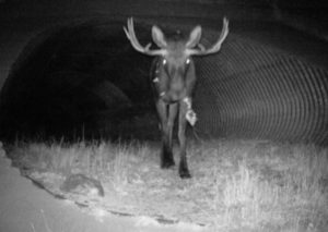
Web-enabled cameras immediately transfer images such as this moose crossing through a culvert on US 91 in Utah. Photo: Fraser Shilling, Road Ecology Center at UC Davis
Working in partnership with the California Department of Transportation and other state departments of transportation, researchers are now further refining commercially-available camera systems to meet the needs of DOTs. The agencies and partners are field testing the camera and database systems to evaluate both their effectiveness in capturing and managing wildlife images and their ease of use.
An integral part of the system is an online database which is set up to receive image files uploaded either by transportation agency staff or directly by the remote, wireless cameras. The system then automatically creates database records for image files based on information already attached to the file, such as the date and time an image was captured. From there, agency biologists can manage, analyze and share the wildlife images.
Transportation agencies in California, Colorado, South Dakota, Virginia and Utah are field testing the technologies, supported by FHWA’s Exploratory Advanced Research Program (FHWA-PROJ-13-0107).
New Era of Wildlife Monitoring
In an era when most of us have nearly instant information concerning most things in our lives, these types of technologies could “up the game” regarding roadside wildlife monitoring, said Fraser Shilling, the principal investigator on the project,
As compared to cameras and sensors used for monitoring traffic and other environmental conditions, camera methods used by state departments of transportation for wildlife monitoring are quite a bit behind, said Shilling, co-director of the Road Ecology Center located at the University of California, Davis.
That’s why the use of advanced imaging technology such as web-enabled cameras potentially could advance the state of the practice on understanding wildlife movements and roadside ecology, and help improve highway safety. Such technologies are important to transportation agencies and society, with costs of wildlife-vehicle collisions estimated to be in the millions of dollars annually.
A recent report issued by the Road Ecology Center and co-authored by Shilling estimated the cost to society of wildlife-vehicle collisions in California in 2015 was around $225 million. The cost of property damage alone was estimated at more than $88 million annually for the state.
FHWA Supports Research
The FHWA is working with state DOTs to promote their wildlife stewardship and public safety missions. Safer wildlife crossings, for instance, are a key component of the FHWA’s efforts to implement Eco-Logical, the landscape-level approach to integrate infrastructure development and ecosystem conservation.
The EAR project is supporting the field testing of cameras and other low-powered sensor systems or unstaffed sensor technologies that will provide data for project delivery, environmental assessment and decision support.
Currently, state DOT biologists monitor wildlife such as deer, bears, mountain lions, elk, and pronghorn sheep using static camera systems in remote locations, known as camera traps, Shilling said. While static camera traps have been useful for gathering data about what types of animals interact with highways, they have some limitations.
Shilling explained that camera traps require the efforts of staff or contractors in order to retrieve pictures or video. One camera trap can yield around 3,500 pictures per month that must be viewed, sorted and recorded. Spread over several miles, a wildlife monitoring project that includes around 50 cameras could result in tens of thousands of pictures to review. Thus, having cameras that stream data to the headquarters office or a web-connected database such as wildlifeobserver.net would allow DOT staff to evaluate pictures within minutes of the animal being sighted.
Colorado DOT SH-9 Project
The Colorado Department of Transportation has used the web-connected cameras as part of its SH-9 Colorado River South Wildlife & Safety Improvement Project. This 10-mile section of highway near Kremmling had more than 500 wildlife-vehicle collisions in the previous 10 years, mostly elk and deer. To monitor the installed mitigation features, CDOT is working on a monitoring study involving more than 60 motion-triggered wildlife cameras, some of which are connected using cellular phone networks, according to Bryan Roeder, CDOT’s Environmental Research Manager.
“The camera data is critical not only for determining the success of the mitigation, but for adaptive management of that mitigation and applying lessons learned to future mitigation,” Roeder said. “This project is expected to produce about one million photos per year, so we are very interested in the future of automated image analysis processes.”
Using the connected cameras, which instantly send photos by e-mail to project researchers, “is a much more convenient method than traditional cameras,” Roeder said. “The ability to view and share photos within minutes of an animal crossing in front of a camera is valuable.”
Jeff Peterson, Manager of CDOT’s Wildlife Program, agrees. “Because SH-9 is the first project in the state to include wildlife overpasses, we are very interested in how effective they are in facilitating connectivity between habitat areas,” and having instant notification from the web-connected cameras is a key component, Peterson said.
Cost Savings
Another issue that such systems would improve upon is the cost—in time and money—for DOTs to maintain camera traps.
Bridget Donaldson, a senior research scientist with the Virginia Department of Transportation, says she is the only one in VDOT that manages the state’s camera traps, relying on university students for help. She hopes to soon install one of the cameras for Shilling’s field test, but for now it takes time to go into the field and visit each camera to gather data and check on battery life.
There would be “huge time savings involved” with the web-enabled cameras, Donaldson said. VDOT currently has a monitoring project along I-64 near Charlottesville, and the time spent visiting each camera to check the number of stored photos would be significantly less since that data would instead be transmitted to her office. Moreover, researchers would know sooner whether cameras are encrusted with winter road salt or knocked out of alignment by snow plows, she said. In cases where cameras are located at some distance from DOT offices, there is simply the travel time to get there.
Also having to pull over on a 70 mile-per-hour interstate to service the cameras presents issues of safety, Donaldson said.
These types of savings can be coupled with savings to society from avoiding animal-vehicle collisions.
In Virginia, Donaldson mentioned that an area VDOT is monitoring outside Charlottesville has deer-vehicle collisions at an average rate of eight per mile per year. Taking into consideration the drain to the economy and the constant potential for loss of human life, this is a rate that justifies VDOT installing fencing along the highway to lead deer and other wildlife to safer underpasses.
Connect With Public, Other Agencies
Shilling sees data being shared with researchers, DOT staff, and the public. For example, in a situation where a DOT has recently installed wildlife crossings to protect mountain lions, if a camera captured a mountain lion using the new structure, the DOT press office could use pictures from the cameras in a news release issued the next day.
Sharing data with other agencies such as fish and game departments could also improve collaboration between departments, Shilling said, and researchers are investigating the use of image analysis software to automate the identification of common wildlife species. The combination of science and public relations becomes increasingly important as public knowledge and awareness can contribute to safer wildlife interactions within rights of way, according to Shilling.
Lessons Learned
The Road Ecology Center tried developing its own web-connected camera but now is mostly testing commercially available systems, Shilling said. With some of the systems that have been tested, the picture resolution is lower than what biologists typically are used to, which manufacturers say permits faster internet transmission.
Camera systems will probably continue to improve as more and more—as many as 100 or 200 at a time, by Shilling’s estimate—are purchased and used by DOTs. The companies that manufacture the systems, which can cost between $100 and $1200 apiece, are beginning to take notice, Shilling said.
Next Steps
The FHWA’s EAR project envisions a system for monitoring wildlife in rights of way that “resembles current traffic flow monitoring systems.” Shilling suggested that creation of wildlife operations centers would “up the game” of wildlife monitoring for transportation agencies.
Using information from the field tests, the researchers will develop short training videos, conduct a webinar, and provide onsite training with DOT staff. The researchers will then present to the FHWA recommended camera and database systems, along with documentation describing how to acquire, set up, and use them.
Also, the researchers will be writing articles describing both the informatics and camera sampling process for publication in peer-reviewed journals. Additionally, the researchers will improve the data associated with the pictures—called EXIF data—to include such information as location and weather. This more complex information will allow biologists and DOT staff to more easily visualize the ecological context of camera placements and will add value to the information being collected, Shilling said.
Information regarding the Road Ecology Center research is available at https://roadecology.ucdavis.edu/research/projects/remote-wireless-camera-systems-environmental-monitoring-transportation-corridors.
For more information on the web-connected wildlife camera research, contact principal investigator Fraser Shilling, co-director of the Road Ecology Center, University of California, Davis, at [email protected] or Deirdre M. Remley, Environmental Protection Specialist/Research Coordinator, FHWA at [email protected].