2025 AASHTO GIS for Transportation Symposium
The 2025 AASHTO GIS for Transportation Symposium is the premier event for geospatial professionals to share how they harness the power of GIS technologies to solve complex problems in transportation.
Home » Geographic Information Systems
The 2025 AASHTO GIS for Transportation Symposium is the premier event for geospatial professionals to share how they harness the power of GIS technologies to solve complex problems in transportation.
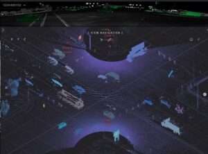
The Utah Department of Transportation is using Light Detection and Ranging or LiDAR technology as a design tool to improve safety at intersections, specifically for pedestrians and bicyclists. [Above image
Your one stop source of environmental information for transportation professionals.